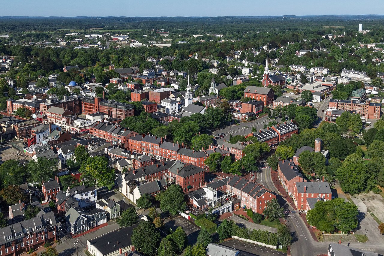
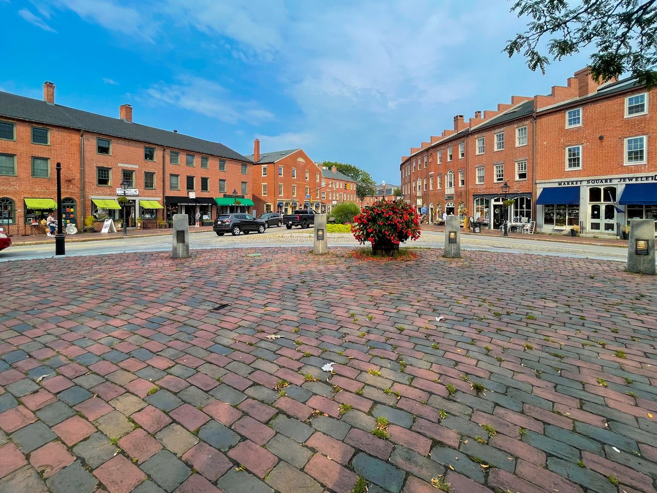
Newburyport is a small city in Essex County about 35 miles north of Boston, on the south bank of the Merrimack River near its mouth. It pairs a walkable brick downtown around Market Square and a long run of Federal-era mansions on High Street with a riverfront park, the northern tip of Plum Island, Maudslay State Park, and the last stop on the Newburyport commuter rail line.
Newburyport was the waterfront part of Newbury until 1764, when its merchants, traders, and craftsmen were set off as a separate town of just 647 acres. Shipbuilding, fishing, and trade made it a busy port, and the decade after 1800 was its high point, when merchants and sea captains built their homes along High Street. The evangelist George Whitefield preached here, died in Newburyport in 1770, and is buried beneath the pulpit of Old South Church.
On May 31, 1811, a fire destroyed nearly 250 buildings across about 16 acres of downtown, and the district was rebuilt in brick, which is why Market Square is lined with Federal-style brick blocks today. Shipyards here built clipper ships in the mid-1800s, mills and shoe factories followed, and Newburyport became a city in 1851 after annexing land from Newbury. In the 1960s and 1970s the city chose to restore its downtown rather than tear it down. Newburyport sits across the Merrimack from Amesbury and Salisbury, with West Newbury to the west, Newbury to the south, and the Atlantic and Plum Island to the east.
Newburyport station, about a mile south of downtown near Route 1, is the end of the Newburyport branch of the MBTA Newburyport/Rockport Line, with direct service to North Station in Boston and a fully accessible high-level platform. The Clipper City Rail Trail, a paved path, links the station with the downtown waterfront. Merrimack Valley Regional Transit Authority buses serve the city, I-95 has an exit at Route 113, U.S. Route 1 runs through the city and crosses the river to Salisbury, and I-495 ends just over the river.
Newburyport real estate is shaped by its Federal-era peak. Federal-style houses dominate the historic neighborhoods, from brick and clapboard merchant mansions on High Street, many with widow's walks, to smaller homes built for mariners, shipbuilders, and artisans on the side streets between High Street and the river. Later 1800s houses, built as the city's mills grew, are simpler in style, and several old brick mills downtown have been converted to apartments.
The Newburyport Historic District, listed on the National Register in 1984, covers most of the historic city between the Merrimack and High Street, with more than 2,500 contributing buildings, and the Market Square Historic District was listed in 1971. Newer neighborhoods spread west and south of High Street toward I-95. Areas include Downtown and Market Square, High Street, the South End and Joppa along the river, the neighborhoods near Atkinson Common, and the Newburyport side of Plum Island, a mix of year-round homes and summer cottages.
Market Square and the streets around it hold the city's downtown shops and restaurants, Waterfront Park and the Harborwalk run along the river, and the Firehouse Center for the Arts holds performances and exhibits in the square. The Custom House Maritime Museum on Water Street, in a granite building designed by Robert Mills in 1835, covers the city's maritime history, and the Cushing House Museum on High Street is a Federal brick mansion from about 1808 and a National Historic Landmark. Bartlet Mall on High Street, with its Frog Pond, sits beside the 1805 courthouse designed by Charles Bulfinch.
Maudslay State Park, a former estate on the Merrimack, has 16 miles of trails and large stands of mountain laurel, and Atkinson Common has a 1930s stone observation tower. On Plum Island, the Newburyport Harbor Light marks a light station that dates to 1788, Plum Island Point Beach faces the river mouth, Mass Audubon's Joppa Flats Education Center sits on the Plum Island Turnpike, and the Parker River National Wildlife Refuge, headquartered in Newburyport, protects most of the island to the south.
What kinds of homes are in Newburyport?
Newburyport has Federal-era mansions on High Street, Federal and later 1800s homes on the side streets near the river, homes in converted brick mills and downtown buildings, newer houses west and south of High Street, and year-round homes and cottages on Plum Island.
How do you get to Boston from Newburyport?
Newburyport station is the end of the Newburyport branch of the MBTA Newburyport/Rockport Line, with direct trains to North Station. By car, I-95 runs south toward Route 128 and Boston, with an exit at Route 113 in the city.
Why is downtown Newburyport built of brick?
A fire on May 31, 1811 destroyed nearly 250 buildings downtown, and the area was rebuilt in brick. Market Square and the streets around it are now a National Register historic district.
To see homes for sale in Newburyport, browse the listings below. Thinking of buying or selling in Newburyport? Call (617) 848-9616 or get a free home valuation. Newburyport is part of our North of Boston guide.
Photos: Quintin Soloviev and Fletcher, CC BY 4.0, via Wikimedia Commons.
18,652 people live in Newburyport, where the median age is 49.8 and the average individual income is $83,895. Data provided by the U.S. Census Bureau.
Total Population
Median Age
Population Density Population Density This is the number of people per square mile in a neighborhood.
Average individual Income
There's plenty to do around Newburyport, including shopping, dining, nightlife, parks, and more. Data provided by Walk Score and Yelp.
Explore popular things to do in the area, including Bella Pepper, Port Beer & Wine, and Port Wine & Spirits.
| Name | Category | Distance | Reviews |
Ratings by
Yelp
|
|---|---|---|---|---|
| Dining | 0.51 miles | 0 reviews | 0/5 stars | |
| Dining · $$ | 0.58 miles | 1 review | 1/5 stars | |
| Dining · $$ | 0.58 miles | 0 reviews | 0/5 stars | |
| Dining | 0.58 miles | 57 reviews | 4.3/5 stars | |
| Dining · $ | 0.58 miles | 13 reviews | 2.1/5 stars | |
| Dining · $$ | 0.59 miles | 23 reviews | 2.7/5 stars | |
| Shopping | 0.64 miles | 0 reviews | 0/5 stars | |
| Active | 0.46 miles | 0 reviews | 0/5 stars | |
| Active | 0.46 miles | 0 reviews | 0/5 stars | |
| Active | 0.5 miles | 0 reviews | 0/5 stars | |
| Active | 0.59 miles | 2 reviews | 1/5 stars | |
| Active | 0.61 miles | 2 reviews | 3/5 stars | |
| Active | 0.65 miles | 0 reviews | 0/5 stars | |
| Active | 0.65 miles | 47 reviews | 2.4/5 stars | |
| Active | 0.67 miles | 0 reviews | 0/5 stars | |
| Active | 0.67 miles | 0 reviews | 0/5 stars | |
| Beauty | 0.38 miles | 2 reviews | 3/5 stars | |
| Beauty | 0.46 miles | 3 reviews | 5/5 stars | |
| Beauty | 0.58 miles | 10 reviews | 4.6/5 stars | |
| Beauty | 0.58 miles | 0 reviews | 0/5 stars | |
| Beauty | 0.58 miles | 0 reviews | 0/5 stars | |
| Beauty | 0.61 miles | 3 reviews | 5/5 stars | |
| Beauty | 0.62 miles | 0 reviews | 0/5 stars | |
| Beauty | 0.66 miles | 0 reviews | 0/5 stars | |
|
|
||||
|
|
||||
|
|
||||
|
|
||||
|
|
||||
|
|
Newburyport has 8,107 households, with an average household size of 2.26. Data provided by the U.S. Census Bureau. Here’s what the people living in Newburyport do for work — and how long it takes them to get there. Data provided by the U.S. Census Bureau. 18,652 people call Newburyport home. The population density is 2,234 and the largest age group is Data provided by the U.S. Census Bureau.
Total Population
Population Density Population Density This is the number of people per square mile in a neighborhood.
Median Age
Men vs Women
Population by Age Group
0-9 Years
10-17 Years
18-24 Years
25-64 Years
65-74 Years
75+ Years
Education Level
Total Households
Average Household Size
Average individual Income
Households with Children
With Children:
Without Children:
Marital Status
Blue vs White Collar Workers
Blue Collar:
White Collar: