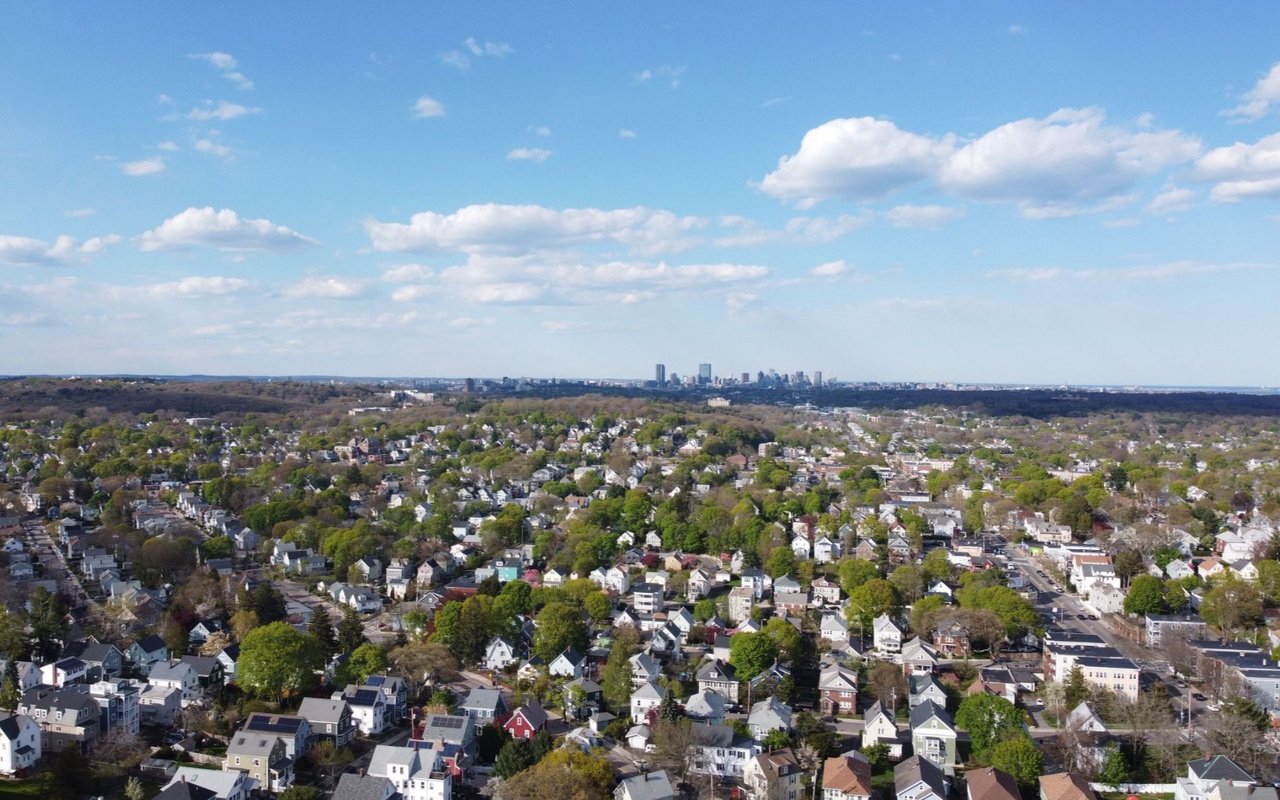
Roslindale is a largely residential neighborhood in southwest Boston, built around Roslindale Village, the historic business district at Roslindale Square. It grew from farmland into a streetcar suburb in the late 1800s and early 1900s, and its streets are lined with detached houses and two-unit homes, many with yards, within reach of the Arnold Arboretum and the Stony Brook Reservation.
Roslindale was originally part of Roxbury, and in 1851 it became part of the new Town of West Roxbury, which broke away to stay rural. The area took its current name in 1870, when the local post office, previously called South Street Crossing, was renamed Roslindale. The Town of West Roxbury, including Roslindale, voted to join Boston in 1873, with annexation taking effect the following year.
Railroad and streetcar service turned the rural village into what the City describes as a garden suburb. Most of the buildings in Roslindale Square went up between 1890 and 1930, and in 1917 the space that is now Adams Park was cleared to create a village green at the center of the district. The Roslindale Substation, built in 1911 for the Boston Elevated Railway to power local trolleys, is a Neo-Classical landmark designed by Robert S. Peabody. In 1985 Roslindale Village became Boston's first Main Street district and one of the first urban Main Street programs in the country, the model for the citywide Boston Main Streets program.
Roslindale borders Jamaica Plain to the north, West Roxbury to the west, Hyde Park to the south, and Mattapan to the east. Its edges are informal, and neighbors often debate exactly where Roslindale ends.
The Needham commuter rail line stops at Roslindale Village and Bellevue, with service to Forest Hills, Ruggles, Back Bay, and South Station. Forest Hills station, just to the north in Jamaica Plain, connects to the Orange Line. Washington Street is the main commercial spine, and Belgrade Avenue, South Street, Cummins Highway, and American Legion Highway carry traffic through the neighborhood.
Housing in Roslindale is mostly detached houses and two-unit homes, many with backyards, built during the neighborhood's growth as a streetcar suburb. Victorian-era and early 20th-century houses share the side streets with two-unit homes and triple-deckers, and condominiums are found in converted houses and in smaller buildings near the Village and along Washington Street.
Roslindale Village is the center of neighborhood life, with independent shops, restaurants, and cafes around Adams Park, where a seasonal farmers market sets up. The Arnold Arboretum borders the neighborhood to the north, and its Peters Hill section, one of the highest points in Boston, offers views of the city skyline and the Blue Hills. To the south, the George Wright Golf Course and the trails of the Stony Brook Reservation add more open space, and local playing fields include Fallon Field and Healy Playground.
What kinds of homes are in Roslindale?
Housing is mostly detached houses and two-unit homes, many with backyards, built as the neighborhood grew into a streetcar suburb. Victorian-era and early 20th-century houses share the side streets with triple-deckers, and condominiums are found in converted houses and smaller buildings near the Village and along Washington Street.
How do you get around from Roslindale?
The Needham commuter rail line stops at Roslindale Village and Bellevue, with service to Forest Hills, Ruggles, Back Bay and South Station. Forest Hills station, just to the north in Jamaica Plain, connects to the Orange Line.
What is Roslindale Village?
Roslindale Village is the historic business district at Roslindale Square, with independent shops, restaurants and cafes around Adams Park, where a seasonal farmers market sets up. In 1985 it became Boston's first Main Street district.
To see homes for sale in Roslindale, browse the listings below. Thinking of buying or selling in Roslindale? Call (617) 848-9616 or get a free home valuation. Roslindale is part of our Boston neighborhood guide.
31,151 people live in Roslindale, where the median age is 39.1 and the average individual income is $59,973. Data provided by the U.S. Census Bureau.
Total Population
Median Age
Population Density Population Density This is the number of people per square mile in a neighborhood.
Average individual Income
There's plenty to do around Roslindale, including shopping, dining, nightlife, parks, and more. Data provided by Walk Score and Yelp.
Explore popular things to do in the area, including Exodus Bagels, Suse's Fashion & Bridals, and May Behavioral Health of Boston.
| Name | Category | Distance | Reviews |
Ratings by
Yelp
|
|---|---|---|---|---|
| Dining | 1.04 miles | 0 reviews | 0/5 stars | |
| Shopping | 0.52 miles | 0 reviews | 0/5 stars | |
| Active | 0.52 miles | 0 reviews | 0/5 stars | |
| Beauty | 0.23 miles | 15 reviews | 4.5/5 stars | |
| Beauty | 0.52 miles | 8 reviews | 4.9/5 stars | |
| Beauty | 0.66 miles | 1 review | 5/5 stars | |
|
|
||||
|
|
||||
|
|
||||
|
|
||||
|
|
||||
|
|
Roslindale has 12,694 households, with an average household size of 2.42. Data provided by the U.S. Census Bureau. Here’s what the people living in Roslindale do for work — and how long it takes them to get there. Data provided by the U.S. Census Bureau. 31,151 people call Roslindale home. The population density is 11,175 and the largest age group is Data provided by the U.S. Census Bureau.
Total Population
Population Density Population Density This is the number of people per square mile in a neighborhood.
Median Age
Men vs Women
Population by Age Group
0-9 Years
10-17 Years
18-24 Years
25-64 Years
65-74 Years
75+ Years
Education Level
Total Households
Average Household Size
Average individual Income
Households with Children
With Children:
Without Children:
Marital Status
Blue vs White Collar Workers
Blue Collar:
White Collar: