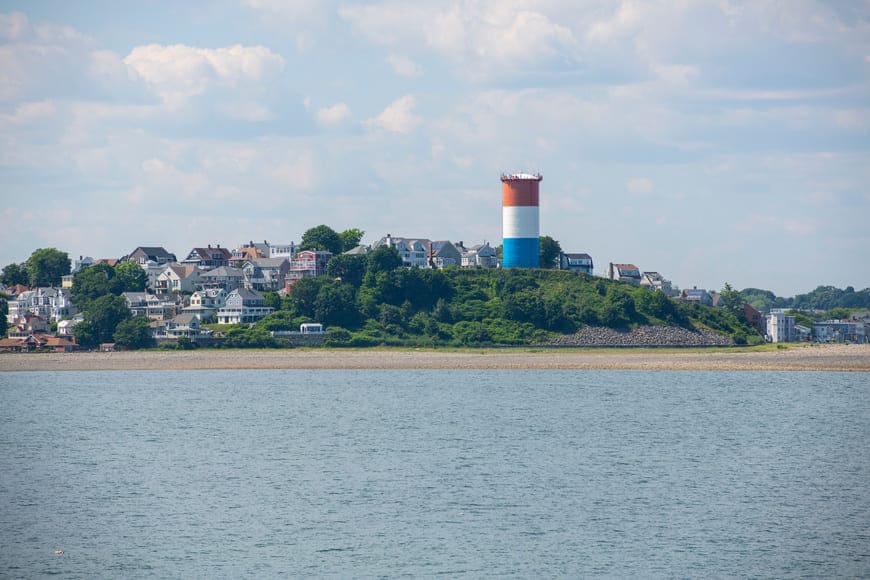
Winthrop is a small seaside town on a peninsula between Boston Harbor and Massachusetts Bay, directly across the water from Logan Airport and downtown Boston. Its compact, hilly streets of Victorian, shingle-style, and early 20th-century homes run between harbor-side neighborhoods and the ocean shoreline of Winthrop Beach, and a seasonal MBTA ferry links the town landing with the Boston waterfront.
Early colonists called the peninsula Pullin Point, a name tied to the boat channel along its shore, and it became part of Boston in the 1630s. Governor John Winthrop held some of the first land here, and his son Deane Winthrop made his home on the point. The Deane Winthrop House, traditionally dated to about 1637, is among the oldest surviving houses in the Boston area. The area went with Chelsea when it separated from Boston in 1739, then with North Chelsea, today's Revere, in 1846, and it was incorporated as the Town of Winthrop in 1852.
Winthrop grew as a summer colony in the late 1800s. A narrow-gauge railroad reached Point Shirley in 1877, land companies laid out neighborhoods such as Ocean Spray and Cottage Hill, and many summer houses had become year-round homes by the 1890s. Fort Banks and Fort Heath were built at the base of Winthrop Highlands in 1891 to defend the harbor. Today Winthrop borders East Boston across the Belle Isle Inlet and Revere to the north, and Deer Island, part of Boston, is reached by road through Point Shirley.
MBTA ferries run from Winthrop Landing to Logan Airport, Central Wharf on the Waterfront, and Fan Pier in the Seaport District. MBTA buses 712 and 713 connect Point Shirley and Winthrop Center with the Blue Line at Orient Heights in East Boston, and Route 145 is the main road through town.
Most of Winthrop's homes date from its resort and streetcar years, from the 1870s into the early 1900s. Queen Anne, Shingle Style, Colonial Revival, and Craftsman houses share the hills with converted summer cottages, bungalows, and early apartment blocks, and two- and three-unit houses, many of them owned as condominiums, are common on the side streets. Along the shore, larger condominium complexes such as Seal Harbor offer views across the water.
Each neighborhood has its own setting. Point Shirley sits at the southern tip near Deer Island, Winthrop Highlands and Cottage Hill rise above the ocean side, Winthrop Beach and Ocean Spray face Massachusetts Bay, and Court Park and the streets around the town center look toward the harbor and the Boston skyline.
Winthrop Beach stretches along the ocean side of town beside Winthrop Shore Drive, part of the state's Winthrop Shore Reservation. On the town's western edge, Belle Isle Marsh Reservation, a state park shared with East Boston and Revere, protects the last salt marsh on Boston's mainland, with walking paths and views across the marsh. Yacht clubs and the public landing line the harbor side, and the Deane Winthrop House keeps the town's earliest history in view.
Winthrop Center, the small downtown, holds local shops, restaurants, and town services, and in season the ferry puts downtown Boston a short ride across the harbor.
To see homes for sale in Winthrop, browse the listings below or contact Berkshire Hathaway HomeServices Warren Residential.
18,807 people live in Winthrop, where the median age is 43.6 and the average individual income is $59,226. Data provided by the U.S. Census Bureau.
Total Population
Median Age
Population Density Population Density This is the number of people per square mile in a neighborhood.
Average individual Income
There's plenty to do around Winthrop, including shopping, dining, nightlife, parks, and more. Data provided by Walk Score and Yelp.
Explore popular things to do in the area, including Ice Cream Shop, Lucky Convenience Mart, and Fab's Liquors.
| Name | Category | Distance | Reviews |
Ratings by
Yelp
|
|---|---|---|---|---|
| Dining | 0.14 miles | 0 reviews | 0/5 stars | |
| Dining | 0.5 miles | 0 reviews | 0/5 stars | |
| Dining · $$$ | 0.84 miles | 2 reviews | 3.5/5 stars | |
| Dining · $$ | 0.85 miles | 1 review | 4/5 stars | |
| Active | 0.5 miles | 0 reviews | 0/5 stars | |
| Active | 0.7 miles | 0 reviews | 0/5 stars | |
| Beauty | 0.2 miles | 1 review | 1/5 stars | |
| Beauty | 0.61 miles | 0 reviews | 0/5 stars | |
|
|
||||
|
|
||||
|
|
||||
|
|
||||
|
|
||||
|
|
Winthrop has 7,918 households, with an average household size of 2.36. Data provided by the U.S. Census Bureau. Here’s what the people living in Winthrop do for work — and how long it takes them to get there. Data provided by the U.S. Census Bureau. 18,807 people call Winthrop home. The population density is 11,348 and the largest age group is Data provided by the U.S. Census Bureau.
Total Population
Population Density Population Density This is the number of people per square mile in a neighborhood.
Median Age
Men vs Women
Population by Age Group
0-9 Years
10-17 Years
18-24 Years
25-64 Years
65-74 Years
75+ Years
Education Level
Total Households
Average Household Size
Average individual Income
Households with Children
With Children:
Without Children:
Marital Status
Blue vs White Collar Workers
Blue Collar:
White Collar: