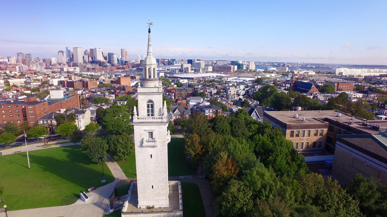
South Boston is a peninsula neighborhood on the south side of Boston Harbor, running from the Fort Point Channel and Dorchester Avenue east to Castle Island and the beaches of Dorchester Bay. Known locally as Southie, it is a neighborhood of triple-deckers, rowhouses, and converted lofts, organized around West and East Broadway and the hills of Dorchester Heights.
The peninsula was once called Mattapannock and later Dorchester Neck, and for most of the colonial era it served as grazing land for the town of Dorchester. It entered American history on the night of March 4, 1776, when Continental troops fortified Dorchester Heights with cannon hauled from Fort Ticonderoga by Henry Knox. Facing the guns, the British evacuated Boston on March 17, 1776. A commemorative tower, dedicated in 1902, stands on the heights in Thomas Park, now part of Boston National Historical Park.
Boston annexed Dorchester Neck in 1804 and built a bridge to it from the South End, and later bridges and streetcar lines tied the peninsula to downtown. Glassworks, foundries, machine shops, and other industry grew up near the channel, and blocks of worker housing followed, while City Point at the eastern end developed with larger homes near the water. The neighborhood borders the Seaport District and Fort Point to the north, Dorchester to the south at Andrew Square, and the South End across the channel to the west.
The Red Line stops at Broadway and Andrew stations, one and two stops from South Station. MBTA buses run along Broadway and the waterfront, Interstate 93 and the Massachusetts Turnpike are at the western edge, and Day Boulevard follows the shore from Castle Island toward Columbia Point.
Much of South Boston's housing is wood-frame triple-deckers and two-unit houses, many now divided into condominiums, along with brick and wood rowhouses on the numbered and lettered streets. Around Broadway station, former printing plants, factories, and warehouses have been converted to lofts, and newer mid-rise condominium buildings have risen along Dorchester Avenue and West Broadway.
South Boston buildings on our site include:
The shoreline is the neighborhood's great open space. Castle Island, a 22-acre state park, holds Fort Independence, a five-sided granite fort built between 1834 and 1851, and a walkway runs from the island past Pleasure Bay, M Street Beach, and Carson Beach toward the Kennedy Library. Medal of Honor Park on Broadway includes the nation's first Vietnam War memorial, and Moakley Park and Flaherty Park add playing fields. West and East Broadway carry most of the shops and restaurants. Every March the South Boston St. Patrick's Day Parade, held here since 1901 and also marking Evacuation Day, follows Broadway from Broadway station past Thomas Park to Andrew Square.
What kinds of homes are in South Boston?
Much of the housing is wood-frame triple-deckers and two-unit houses, many now condominiums, along with brick and wood rowhouses on the numbered and lettered streets. Around Broadway station, former printing plants, factories and warehouses have been converted to lofts, and newer mid-rise condominiums line Dorchester Avenue and West Broadway.
How do you get around from South Boston?
The Red Line stops at Broadway and Andrew stations, one and two stops from South Station. MBTA buses run along Broadway and the waterfront, and Interstate 93 and the Massachusetts Turnpike are at the western edge.
What is Castle Island?
Castle Island is a 22-acre state park that holds Fort Independence, a five-sided granite fort built between 1834 and 1851. A walkway runs from the island past Pleasure Bay, M Street Beach and Carson Beach toward the Kennedy Library.
To see homes for sale in South Boston, browse the listings below. Thinking of buying or selling in South Boston? Call (617) 848-9616 or get a free home valuation. South Boston is part of our Boston neighborhood guide.
36,769 people live in South Boston, where the median age is 32.3 and the average individual income is $99,163. Data provided by the U.S. Census Bureau.
Total Population
Median Age
Population Density Population Density This is the number of people per square mile in a neighborhood.
Average individual Income
There's plenty to do around South Boston, including shopping, dining, nightlife, parks, and more. Data provided by Walk Score and Yelp.
Explore popular things to do in the area, including Boston Food Truck Alliance, The Store 24, and B & 4th Street Variety.
| Name | Category | Distance | Reviews |
Ratings by
Yelp
|
|---|---|---|---|---|
| Dining | 0.17 miles | 0 reviews | 0/5 stars | |
| Dining | 0.23 miles | 0 reviews | 0/5 stars | |
| Dining · $ | 0.95 miles | 3 reviews | 2.3/5 stars | |
| Active | 0.22 miles | 0 reviews | 0/5 stars | |
| Active | 0.41 miles | 0 reviews | 0/5 stars | |
| Active | 0.72 miles | 8 reviews | 3.5/5 stars | |
| Beauty | 0.17 miles | 2 reviews | 5/5 stars | |
| Beauty | 0.52 miles | 1 review | 5/5 stars | |
| Beauty | 0.63 miles | 0 reviews | 0/5 stars | |
| Beauty | 0.89 miles | 0 reviews | 0/5 stars | |
| Beauty | 1.04 miles | 1 review | 5/5 stars | |
|
|
||||
|
|
||||
|
|
||||
|
|
||||
|
|
||||
|
|
South Boston has 18,066 households, with an average household size of 2.02. Data provided by the U.S. Census Bureau. Here’s what the people living in South Boston do for work — and how long it takes them to get there. Data provided by the U.S. Census Bureau. 36,769 people call South Boston home. The population density is 17,869 and the largest age group is Data provided by the U.S. Census Bureau.
Total Population
Population Density Population Density This is the number of people per square mile in a neighborhood.
Median Age
Men vs Women
Population by Age Group
0-9 Years
10-17 Years
18-24 Years
25-64 Years
65-74 Years
75+ Years
Education Level
Total Households
Average Household Size
Average individual Income
Households with Children
With Children:
Without Children:
Marital Status
Blue vs White Collar Workers
Blue Collar:
White Collar: