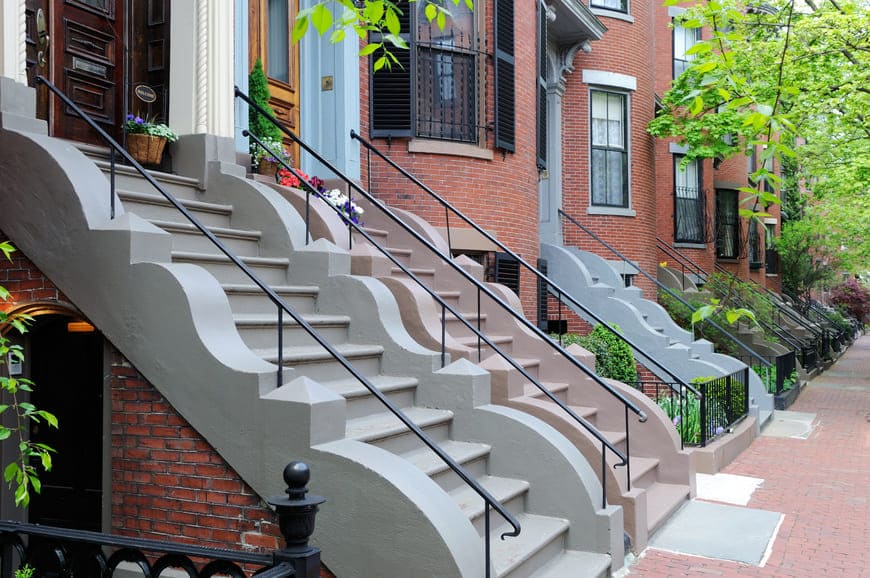
The South End is a historic Boston neighborhood of Victorian brick rowhouses and small residential squares, located south of Back Bay and Bay Village between Massachusetts Avenue and Interstate 93. The South End Historical Society notes that it is listed on the National Register of Historic Places as the largest Victorian brick rowhouse district in the United States.
The neighborhood was built on filled marshland on both sides of the Neck, the narrow strip of land that once connected Boston to Roxbury and is now Washington Street. After the marsh was filled, development began around 1850, when builders put up long, uniform rows of fashionable townhouses. Limits on building size and materials gave the area its remarkable consistency, and the street plan followed English models, with rows of houses facing small landscaped squares such as Union Park, Rutland Square, Concord Square, and Worcester Square. After the Panic of 1873 many wealthy households moved to the new Back Bay, and many of the large houses became lodging houses.
Today the city's South End Landmark District reviews exterior changes to the historic rowhouses. The neighborhood borders Back Bay and Bay Village to the north, Chinatown to the northeast, Roxbury to the south, and Fenway / Kenmore to the west, with South Boston across the highway and Fort Point Channel. On the eastern side, Harrison Avenue and Albany Street were once home to warehouses and factories, and the area now known as SoWa holds galleries, artist studios, and converted lofts.
The Orange Line runs along the neighborhood's western edge beneath Southwest Corridor Park, with stops at Back Bay and Massachusetts Avenue. Silver Line SL4 and SL5 buses run along Washington Street to Downtown and Nubian Square, and Prudential and Symphony stations on the Green Line are close to the western blocks. Interstate 93 and the Massachusetts Turnpike are at the neighborhood's edge.
Most homes are three- to five-story bow-front brick and brownstone rowhouses from the 1850s through the 1870s, many divided into condominiums and many with original cast-iron railings and stoops. Toward Harrison Avenue and Washington Street, former industrial buildings have been converted to lofts, and newer mid-rise buildings line the Washington Street and Ink Block area.
South End buildings on our site include:
More buildings are listed on our Developments page.
Tremont Street and Shawmut Avenue are lined with restaurants, cafes, and shops, and Washington Street has more along the SoWa stretch. The SoWa Open Market on Harrison Avenue runs on Sundays in season. The Boston Center for the Arts occupies the 1884 Cyclorama building on Tremont Street, and Blackstone and Franklin Squares, Peters Park, and the Southwest Corridor Park add green space.
To see homes for sale in the South End, browse the listings below or contact Berkshire Hathaway HomeServices Warren Residential.
28,414 people live in South End, where the median age is 40 and the average individual income is $118,222. Data provided by the U.S. Census Bureau.
Total Population
Median Age
Population Density Population Density This is the number of people per square mile in a neighborhood.
Average individual Income
There's plenty to do around South End, including shopping, dining, nightlife, parks, and more. Data provided by Walk Score and Yelp.
Explore popular things to do in the area, including San Juan Market, Medina's Mkt, and Sales Trend Network.
| Name | Category | Distance | Reviews |
Ratings by
Yelp
|
|---|---|---|---|---|
| Dining | 0.1 miles | 0 reviews | 0/5 stars | |
| Dining | 0.17 miles | 0 reviews | 0/5 stars | |
| Dining | 0.19 miles | 0 reviews | 0/5 stars | |
| Dining · $$ | 0.23 miles | 12 reviews | 1.7/5 stars | |
| Active | 0.26 miles | 0 reviews | 0/5 stars | |
| Active | 0.26 miles | 0 reviews | 0/5 stars | |
| Active | 0.26 miles | 0 reviews | 0/5 stars | |
| Active | 0.26 miles | 0 reviews | 0/5 stars | |
| Active | 0.26 miles | 0 reviews | 0/5 stars | |
| Active | 0.26 miles | 0 reviews | 0/5 stars | |
| Active | 0.26 miles | 0 reviews | 0/5 stars | |
| Active | 0.26 miles | 0 reviews | 0/5 stars | |
| Active | 0.29 miles | 0 reviews | 0/5 stars | |
| Active | 0.32 miles | 0 reviews | 0/5 stars | |
| Active | 0.37 miles | 0 reviews | 0/5 stars | |
| Active | 0.41 miles | 0 reviews | 0/5 stars | |
| Active | 0.46 miles | 0 reviews | 0/5 stars | |
| Active | 0.47 miles | 1 review | 1/5 stars | |
| Active | 0.47 miles | 0 reviews | 0/5 stars | |
| Active | 0.47 miles | 0 reviews | 0/5 stars | |
| Beauty | 0.26 miles | 0 reviews | 0/5 stars | |
| Beauty | 0.26 miles | 3 reviews | 4/5 stars | |
| Beauty | 0.29 miles | 10 reviews | 3.8/5 stars | |
| Beauty | 0.38 miles | 0 reviews | 0/5 stars | |
|
|
||||
|
|
||||
|
|
||||
|
|
||||
|
|
||||
|
|
South End has 14,753 households, with an average household size of 2. Data provided by the U.S. Census Bureau. Here’s what the people living in South End do for work — and how long it takes them to get there. Data provided by the U.S. Census Bureau. 28,414 people call South End home. The population density is 43,754 and the largest age group is Data provided by the U.S. Census Bureau.
Total Population
Population Density Population Density This is the number of people per square mile in a neighborhood.
Median Age
Men vs Women
Population by Age Group
0-9 Years
10-17 Years
18-24 Years
25-64 Years
65-74 Years
75+ Years
Education Level
Total Households
Average Household Size
Average individual Income
Households with Children
With Children:
Without Children:
Marital Status
Blue vs White Collar Workers
Blue Collar:
White Collar: