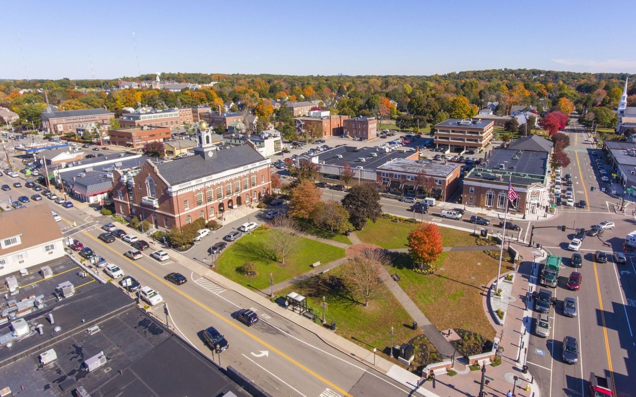
Needham is a town in Norfolk County southwest of Boston, set on rocky uplands within a broad loop of the Charles River. Incorporated in 1711, it is a largely residential suburb organized around two villages, Needham Center and Needham Heights, with four commuter rail stations and Route 128 along its eastern edge.
Needham began as part of the land granted to Dedham in 1636 and served as Dedham's common land through the 17th century. In 1681 the land was purchased from William Nehoiden, and after residents petitioned for their own township, the town was established on November 6, 1711. Early Needham was a place of farms, orchards, and saw and grist mills along the Charles.
The railroad reached the Great Plain in 1853, and the village that grew up where Great Plain Avenue meets Highland Avenue became today's Needham Center. Knitting mills followed, with knitters from the English Midlands settling here and the William Carter Company becoming the best known of the local manufacturers, centered in Highlandville, now Needham Heights. In 1881 West Needham separated to become the town of Wellesley. After Route 128 opened in 1951, Needham grew into the suburb it is today. The town borders Wellesley, Newton, Boston's West Roxbury neighborhood, Dedham, Westwood, and Dover.
The Needham Line of the commuter rail stops at Needham Heights, Needham Center, Needham Junction, and Hersey stations, then runs through West Roxbury and Roslindale to Back Bay and South Station. Route 128 and Interstate 95 follow the Charles along the eastern side of town, and Great Plain Avenue and Highland Avenue are the main local streets.
Most homes in Needham are single-family houses, along with condominiums, townhouses, and a smaller number of apartment buildings. The housing traces the town's growth. Italianate and Second Empire houses from the 1850s onward survive near Great Plain Avenue, and Queen Anne, Victorian Gothic, and early 20th-century houses fill the blocks between Highland Avenue and Webster Street. Country estates were assembled along South Street and River Street near the Charles around the turn of the 20th century, and between the world wars builders added Dutch Colonial and Colonial Revival houses, Tudor-style homes near the rail line, and subdivisions east of Webster Street, some with planted center strips. In recent decades many modest older houses have been replaced with larger new homes, and the town has adopted rules on the size of new construction. The Colonial Revival Town Hall of 1902 anchors the Needham Town Hall Historic District, listed on the National Register of Historic Places.
Needham Center, around the Town Common, is the town's main gathering place, with shops and restaurants along Great Plain Avenue and Chapel Street. The Needham History Center and Museum on Central Avenue has been telling the town's story since 1915.
The Charles River shapes much of the outdoor life. The Trustees' Charles River Peninsula is a 30-acre meadow and woodland surrounded by the river on three sides, and the state's Cutler Park Reservation protects 600 acres, including the largest freshwater marsh on the middle Charles, with a loop trail around Kendrick Pond. The Needham Town Forest, with the views from High Rock, Ridge Hill Reservation, and Rosemary Lake near Needham Center add more wooded trails close to home.
To see homes for sale in Needham, browse the listings below or contact Berkshire Hathaway HomeServices Warren Residential.
32,059 people live in Needham, where the median age is 43 and the average individual income is $100,288. Data provided by the U.S. Census Bureau.
Total Population
Median Age
Population Density Population Density This is the number of people per square mile in a neighborhood.
Average individual Income
There's plenty to do around Needham, including shopping, dining, nightlife, parks, and more. Data provided by Walk Score and Yelp.
Explore popular things to do in the area, including Northeastern Sales Solutions, Winchester Psychological Associates, and Corbett Darlene M Socl Workr.
| Name | Category | Distance | Reviews |
Ratings by
Yelp
|
|---|---|---|---|---|
| Dining | 0.39 miles | 0 reviews | 0/5 stars | |
| Active | 0.1 miles | 0 reviews | 0/5 stars | |
| Active | 0.19 miles | 0 reviews | 0/5 stars | |
| Active | 0.19 miles | 0 reviews | 0/5 stars | |
| Active | 0.21 miles | 0 reviews | 0/5 stars | |
| Active | 0.24 miles | 0 reviews | 0/5 stars | |
| Active | 0.32 miles | 0 reviews | 0/5 stars | |
| Active | 0.32 miles | 0 reviews | 0/5 stars | |
| Active | 0.32 miles | 0 reviews | 0/5 stars | |
| Active | 0.33 miles | 0 reviews | 0/5 stars | |
| Active | 0.36 miles | 0 reviews | 0/5 stars | |
| Active | 0.37 miles | 0 reviews | 0/5 stars | |
| Active | 0.39 miles | 0 reviews | 0/5 stars | |
| Active | 0.41 miles | 0 reviews | 0/5 stars | |
| Active | 0.41 miles | 0 reviews | 0/5 stars | |
| Active | 0.46 miles | 0 reviews | 0/5 stars | |
| Active | 0.46 miles | 0 reviews | 0/5 stars | |
| Active | 0.52 miles | 0 reviews | 0/5 stars | |
| Active | 0.52 miles | 0 reviews | 0/5 stars | |
| Active | 0.52 miles | 0 reviews | 0/5 stars | |
| Active | 0.56 miles | 0 reviews | 0/5 stars | |
| Beauty | 0.14 miles | 0 reviews | 0/5 stars | |
| Beauty | 0.2 miles | 25 reviews | 2.9/5 stars | |
| Beauty | 0.24 miles | 0 reviews | 0/5 stars | |
|
|
||||
|
|
||||
|
|
||||
|
|
||||
|
|
||||
|
|
Needham has 11,401 households, with an average household size of 2.75. Data provided by the U.S. Census Bureau. Here’s what the people living in Needham do for work — and how long it takes them to get there. Data provided by the U.S. Census Bureau. 32,059 people call Needham home. The population density is 2,607 and the largest age group is Data provided by the U.S. Census Bureau.
Total Population
Population Density Population Density This is the number of people per square mile in a neighborhood.
Median Age
Men vs Women
Population by Age Group
0-9 Years
10-17 Years
18-24 Years
25-64 Years
65-74 Years
75+ Years
Education Level
Total Households
Average Household Size
Average individual Income
Households with Children
With Children:
Without Children:
Marital Status
Blue vs White Collar Workers
Blue Collar:
White Collar: