Saugus is a town in Essex County a short distance north of Boston, on the Saugus and Pines rivers. It is home to Saugus Iron Works National Historic Site, where the first successful ironworks in colonial America operated, along with Breakheart Reservation, the Rumney Marsh salt marsh, and the commercial corridor of U.S. Route 1.
The area was settled in 1629 as part of the Lynn plantation, and its name comes from an Algonquian word. In the 1640s an English company built an ironworks on the Saugus River, and from 1646 to about 1670 it produced cast and wrought iron. The village that grew around it became known as Hammersmith. Saugus served as Lynn's west parish before it separated and was incorporated as a town in 1815. Mills along the river later made snuff, chocolate, woolen cloth, and leather, while East Saugus became a shoemaking center and Cliftondale grew into a busy commercial village.
In 1937 the old Newburyport Turnpike was rebuilt as Route 1, and the highway became a corridor of motels, restaurants, showrooms, and shopping centers. Saugus borders Lynnfield to the north, Wakefield to the northwest, Lynn to the east, Revere to the south, and Melrose to the west.
Saugus has no rail station, but MBTA buses connect it with rapid transit and downtown Boston. Route 430 runs from Saugus Center to Malden Center on the Orange Line, route 426 crosses Saugus between Lynn and Haymarket, and route 428 links Oaklandvale with Haymarket. Several routes also reach Wonderland station on the Blue Line in Revere. U.S. Route 1 runs north and south through town, and Route 107 follows the old Salem Turnpike.
Saugus real estate ranges from the 1600s to the postwar years. The Boardman House, built around 1687, is the town's best-known early house, and five-bay, center-chimney houses represent the 1700s. Federal houses, Greek Revival and Italianate gable-front homes, and later Queen Anne houses, four-squares, two-family houses, and three-deckers followed as the villages grew along the river and the streetcar lines.
Between the world wars, bungalows and Colonial Revival houses filled smaller lots in new subdivisions such as Lynnhurst, Pleasant Hills, and Oaklandvale. Saugus Center remains the civic core, with East Saugus, Cliftondale, and North Saugus as the town's other historic villages.
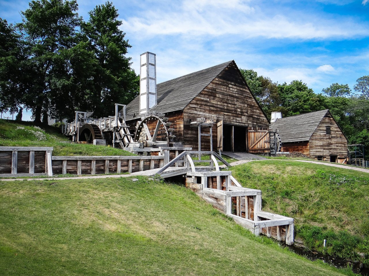
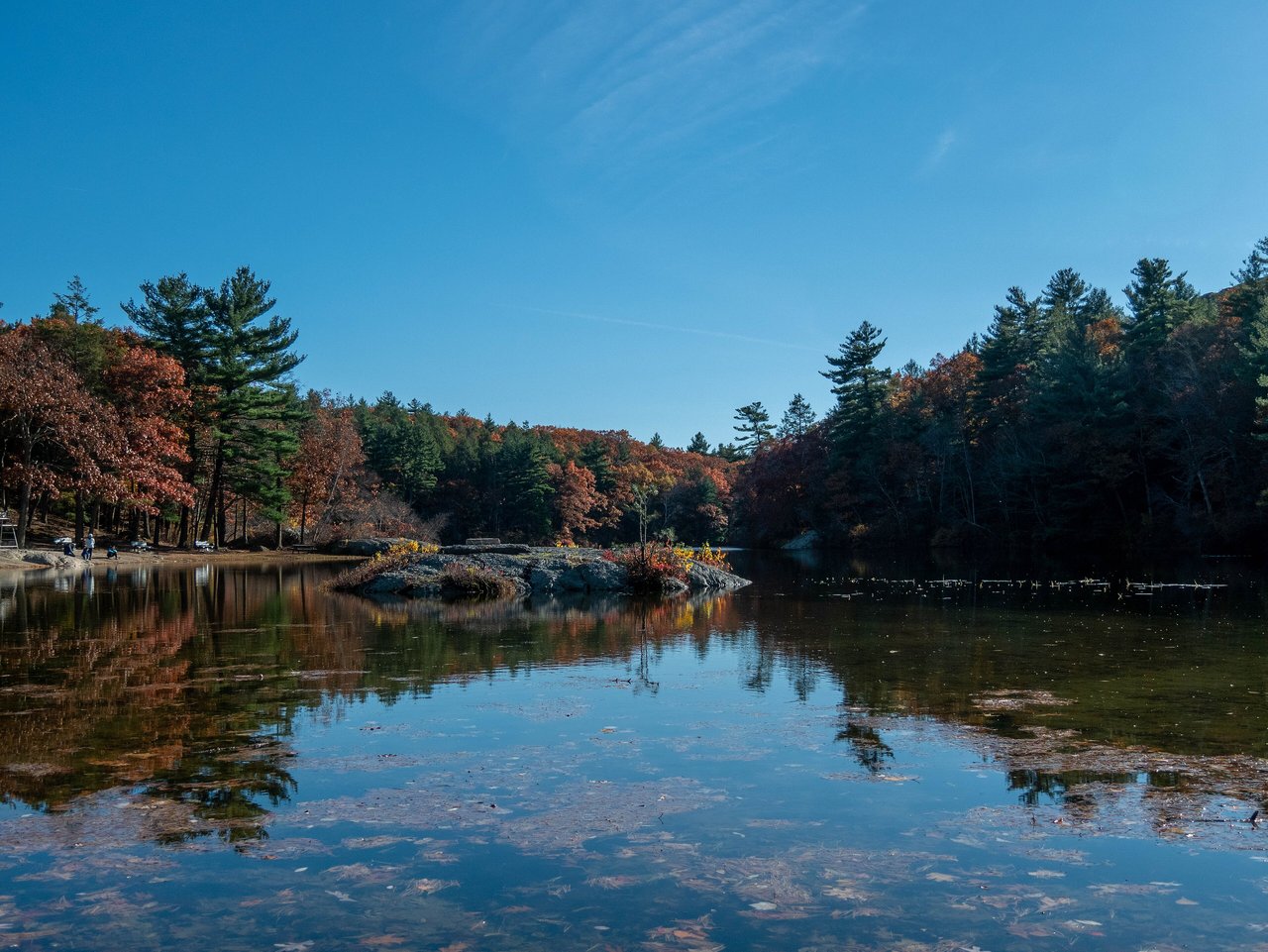
Saugus Iron Works National Historic Site covers twelve acres on the banks of the Saugus River, with working waterwheels, a reconstructed blast furnace and forge, and the 17th-century Iron Works House, restored in 1916. Breakheart Reservation has two lakes and a large forest, with hiking and paved walking trails, supervised swimming at Pearce Lake, and overlooks with views of Boston, New Hampshire, and central Massachusetts.
Where the Saugus and Pines rivers meet, the Rumney Marsh Reservation protects a 600-acre salt marsh for birdwatching, fishing, and boating. The Northern Strand Community Trail crosses Saugus on a former rail line between Everett and Lynn, and Saugus Center, with its town hall and meetinghouse site, is the town's civic heart.
What kinds of homes are in Saugus?
Saugus has a few houses from the 1600s and 1700s, Federal and Greek Revival homes, and Queen Anne houses, two-family houses, and three-deckers from the late 1800s. Bungalows and Colonial Revival houses fill the subdivisions built between the world wars.
How do you get to Boston from Saugus?
MBTA bus route 430 runs to Malden Center on the Orange Line, and routes 426 and 428 run to Haymarket in Boston. Other routes reach Wonderland station on the Blue Line, and U.S. Route 1 runs south toward Boston.
What is the Saugus Iron Works?
Saugus Iron Works National Historic Site preserves the site of the first successful ironworks in colonial America, which made iron from 1646 to about 1670. The twelve-acre site has reconstructed ironworks, working waterwheels, and the 17th-century Iron Works House.
To see homes for sale in Saugus, browse the listings below. Thinking of buying or selling in Saugus? Call (617) 848-9616 or get a free home valuation. Saugus is part of our North of Boston guide.
Photos: U.S. Geological Survey from Reston, VA, USA (Public domain) and Joseph Reagle, CC BY-SA 4.0, via Wikimedia Commons.
28,773 people live in Saugus, where the median age is 44.5 and the average individual income is $48,230. Data provided by the U.S. Census Bureau.
Total Population
Median Age
Population Density Population Density This is the number of people per square mile in a neighborhood.
Average individual Income
There's plenty to do around Saugus, including shopping, dining, nightlife, parks, and more. Data provided by Walk Score and Yelp.
Explore popular things to do in the area, including Gageway Newstand, Ronnie's Cafe, and Boston North Fitness Centers.
| Name | Category | Distance | Reviews |
Ratings by
Yelp
|
|---|---|---|---|---|
| Dining | 0.83 miles | 0 reviews | 0/5 stars | |
| Dining | 1.75 miles | 0 reviews | 0/5 stars | |
| Active | 0.73 miles | 0 reviews | 0/5 stars | |
| Active | 1.17 miles | 0 reviews | 0/5 stars | |
| Active | 1.99 miles | 26 reviews | 2.5/5 stars | |
| Beauty | 0.36 miles | 5 reviews | 2.6/5 stars | |
| Beauty | 0.75 miles | 2 reviews | 3.5/5 stars | |
| Beauty | 0.91 miles | 0 reviews | 0/5 stars | |
| Beauty | 1.02 miles | 14 reviews | 4.7/5 stars | |
| Beauty | 1.08 miles | 0 reviews | 0/5 stars | |
| Beauty | 1.08 miles | 4 reviews | 4/5 stars | |
| Beauty | 1.4 miles | 6 reviews | 5/5 stars | |
| Beauty | 1.4 miles | 0 reviews | 0/5 stars | |
| Beauty | 1.51 miles | 1 review | 1/5 stars | |
|
|
||||
|
|
||||
|
|
||||
|
|
||||
|
|
||||
|
|
Saugus has 10,958 households, with an average household size of 2.6. Data provided by the U.S. Census Bureau. Here’s what the people living in Saugus do for work — and how long it takes them to get there. Data provided by the U.S. Census Bureau. 28,773 people call Saugus home. The population density is 2,670 and the largest age group is Data provided by the U.S. Census Bureau.
Total Population
Population Density Population Density This is the number of people per square mile in a neighborhood.
Median Age
Men vs Women
Population by Age Group
0-9 Years
10-17 Years
18-24 Years
25-64 Years
65-74 Years
75+ Years
Education Level
Total Households
Average Household Size
Average individual Income
Households with Children
With Children:
Without Children:
Marital Status
Blue vs White Collar Workers
Blue Collar:
White Collar: