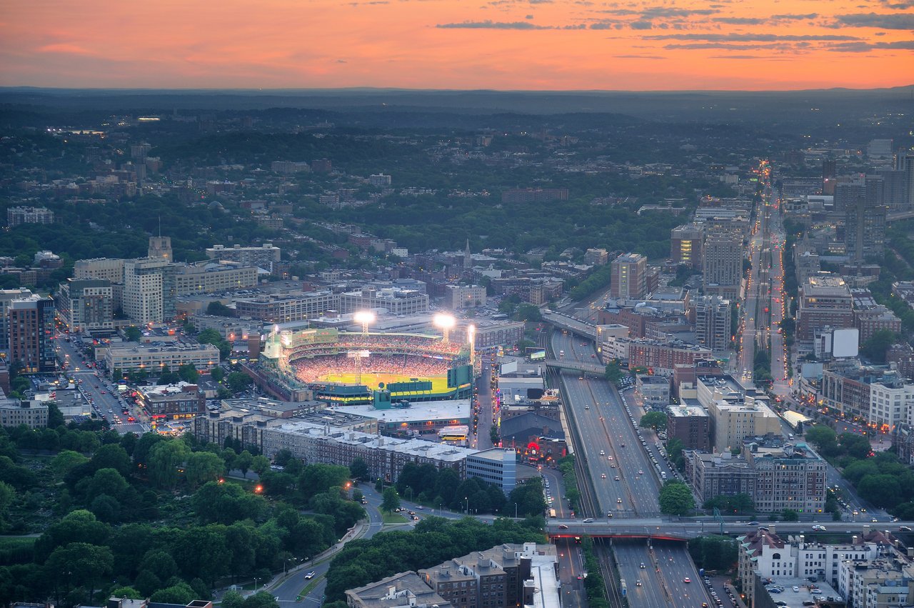
Fenway / Kenmore is the Boston neighborhood that surrounds the Back Bay Fens, just west of the Back Bay, stretching from Kenmore Square and the Charles River south to the museums of Huntington Avenue and the Longwood Medical Area. It is home to Fenway Park, the Museum of Fine Arts, Symphony Hall, and the Isabella Stewart Gardner Museum, along with brick apartment blocks from the early 1900s and a newer generation of towers along Boylston Street and Brookline Avenue.
Much of the neighborhood was once tidal marsh. In 1878 the City of Boston hired Frederick Law Olmsted to clean up the polluted marsh at the edge of the new Back Bay, and his plan turned it into the Back Bay Fens, the first link in what became the Emerald Necklace park system. Filling of the surrounding land was completed in 1898, and institutions followed. Symphony Hall opened in 1900, the Gardner Museum in 1903, and the Museum of Fine Arts moved to its Guy Lowell building on Huntington Avenue in 1909. Fenway Park opened on April 20, 1912, and is the oldest ballpark still in use in Major League Baseball.
The neighborhood includes Kenmore Square and Bay State Road near the river, Audubon Circle, the East Fens around Symphony Hall, and the West Fens along Boylston Street. Its listings on our site also cover the Longwood area, home to the Longwood Medical and Academic Area, whose institutions include Beth Israel Deaconess, Brigham and Women's, Boston Children's Hospital, and Dana-Farber. Fenway / Kenmore borders Back Bay to the east, the South End and Roxbury to the southeast, Mission Hill to the south, and Brookline across the Riverway, with Allston/Brighton to the west.
Kenmore station connects the B, C, and D branches of the Green Line, and the D branch also stops at Fenway and Longwood. The E branch runs along Huntington Avenue with stops at Symphony, Northeastern University, Museum of Fine Arts, and Longwood Medical Area. Lansdowne station, beside Fenway Park, is on the Framingham/Worcester commuter rail line, and Storrow Drive and the Massachusetts Turnpike run along the edges.
Housing in the neighborhood spans more than a century. Bay State Road, laid out in 1889 and mostly built in the late 1890s, has revival-style townhouses protected by the Bay State Road/Back Bay West Architectural Conservation District. Streets near the Fens hold brick and stone apartment buildings from the early 20th century, many now condominiums, while Boylston Street and Brookline Avenue have filled in with mid- and high-rise buildings since the 2000s.
Fenway / Kenmore buildings on our site include:
The Back Bay Fens anchor daily life, with the Kelleher Rose Garden, ball fields, paths along the Muddy River, and the Fenway Victory Gardens, the last of the original World War II victory gardens in the country. Game days fill Lansdowne and Jersey Streets around the ballpark, and Boylston Street has added restaurants and shops at the base of its newer buildings. Kenmore Square, where the Citgo sign has stood since 1965, leads to Boston University's Bay State Road.
What kinds of homes are in Fenway / Kenmore?
Streets near the Fens hold brick and stone apartment buildings from the early 20th century, many now condominiums, and Bay State Road has revival-style townhouses built mostly in the late 1890s. Boylston Street and Brookline Avenue have filled in with mid- and high-rise buildings since the 2000s.
How do you get around from Fenway / Kenmore?
Kenmore station connects the B, C and D branches of the Green Line, and the E branch runs along Huntington Avenue with stops at Symphony, Northeastern University, Museum of Fine Arts and Longwood Medical Area. Lansdowne station, beside Fenway Park, is on the Framingham/Worcester commuter rail line.
What parks are in Fenway / Kenmore?
The Back Bay Fens, the first link in Frederick Law Olmsted's Emerald Necklace, anchor the neighborhood. They include the Kelleher Rose Garden, ball fields, paths along the Muddy River, and the Fenway Victory Gardens, the last of the original World War II victory gardens in the country.
To see homes for sale in Fenway / Kenmore, browse the listings below. Thinking of buying or selling in Fenway / Kenmore? Call (617) 848-9616 or get a free home valuation. Fenway / Kenmore is part of our Boston neighborhood guide.
41,747 people live in Fenway / Kenmore, where the median age is 27 and the average individual income is $47,741. Data provided by the U.S. Census Bureau.
Total Population
Median Age
Population Density Population Density This is the number of people per square mile in a neighborhood.
Average individual Income
There's plenty to do around Fenway / Kenmore, including shopping, dining, nightlife, parks, and more. Data provided by Walk Score and Yelp.
Explore popular things to do in the area, including Dunkin', Atlas Music, and Vietnam Veterans Memorial.
| Name | Category | Distance | Reviews |
Ratings by
Yelp
|
|---|---|---|---|---|
| Dining | 0.6 miles | 0 reviews | 0/5 stars | |
| Shopping | 0.57 miles | 0 reviews | 0/5 stars | |
| Active | 0.23 miles | 0 reviews | 0/5 stars | |
| Active | 0.37 miles | 11 reviews | 4.7/5 stars | |
| Active | 0.48 miles | 0 reviews | 0/5 stars | |
| Active | 0.48 miles | 0 reviews | 0/5 stars | |
| Active | 0.57 miles | 0 reviews | 0/5 stars | |
| Nightlife | 0.63 miles | 226 reviews | 4.4/5 stars | |
| Beauty | 0.38 miles | 0 reviews | 0/5 stars | |
| Beauty | 0.57 miles | 24 reviews | 4/5 stars | |
|
|
||||
|
|
||||
|
|
||||
|
|
||||
|
|
||||
|
|
Fenway / Kenmore has 12,414 households, with an average household size of 2. Data provided by the U.S. Census Bureau. Here’s what the people living in Fenway / Kenmore do for work — and how long it takes them to get there. Data provided by the U.S. Census Bureau. 41,747 people call Fenway / Kenmore home. The population density is 56,756 and the largest age group is Data provided by the U.S. Census Bureau.
Total Population
Population Density Population Density This is the number of people per square mile in a neighborhood.
Median Age
Men vs Women
Population by Age Group
0-9 Years
10-17 Years
18-24 Years
25-64 Years
65-74 Years
75+ Years
Education Level
Total Households
Average Household Size
Average individual Income
Households with Children
With Children:
Without Children:
Marital Status
Blue vs White Collar Workers
Blue Collar:
White Collar: